|
The Evidence By Brian Orr Have a question? Click Here to go to Brian's own Discussion Board!
Two witnesses to a Balliol of Urr Charter of 1262 were described as burgesses of Urr. In the Ragmans Rolls, declaring allegiance to Edward I in 1269, Hughe de Urre del Counte de Dumfres appears. His lands were later given to Henry de Percy who had been appointed Keeper of Galloway.
What these references indicate is that an area of land called Urr had already been defined and made a barony by the mid 1200s.
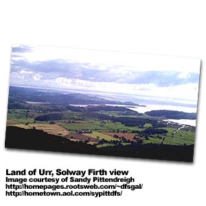
A map by Chatelain & Guerdeville, dated 1720, in the Museum of Scotland shows the village of Orr just south of Dumfries. A search of the 1841, 1851 and 1881 Censuses, however, shows few Orrs in the area; in 1881 there was only one family of Urr/Orr then in Kirkcudbright, being a dwelling at Auldon Bank, Troqueer.
The Motte of Urr is said to be the most extensive motte and bailey castle in Scotland and may well have been built on the site of an earlier Anglo Saxon fort. Excavation at the top showed that the topmost two metres had been added after a 12th century fire had destroyed timber fences and houses.
There was a rectangular wooden tower or blockhouse in the middle of the motte and a timber palisade with foxholes or pits around the edge for archers to fire down through the slits or embrasures. There is evidence of rebuilding and new foxholes added after the fire. Coins and pottery indicate that there had been occupants until the 14th century.
You can talk to Brian Orr on his own Discussion Board or you can click here to read more about his extensive research on the Orr family name. |